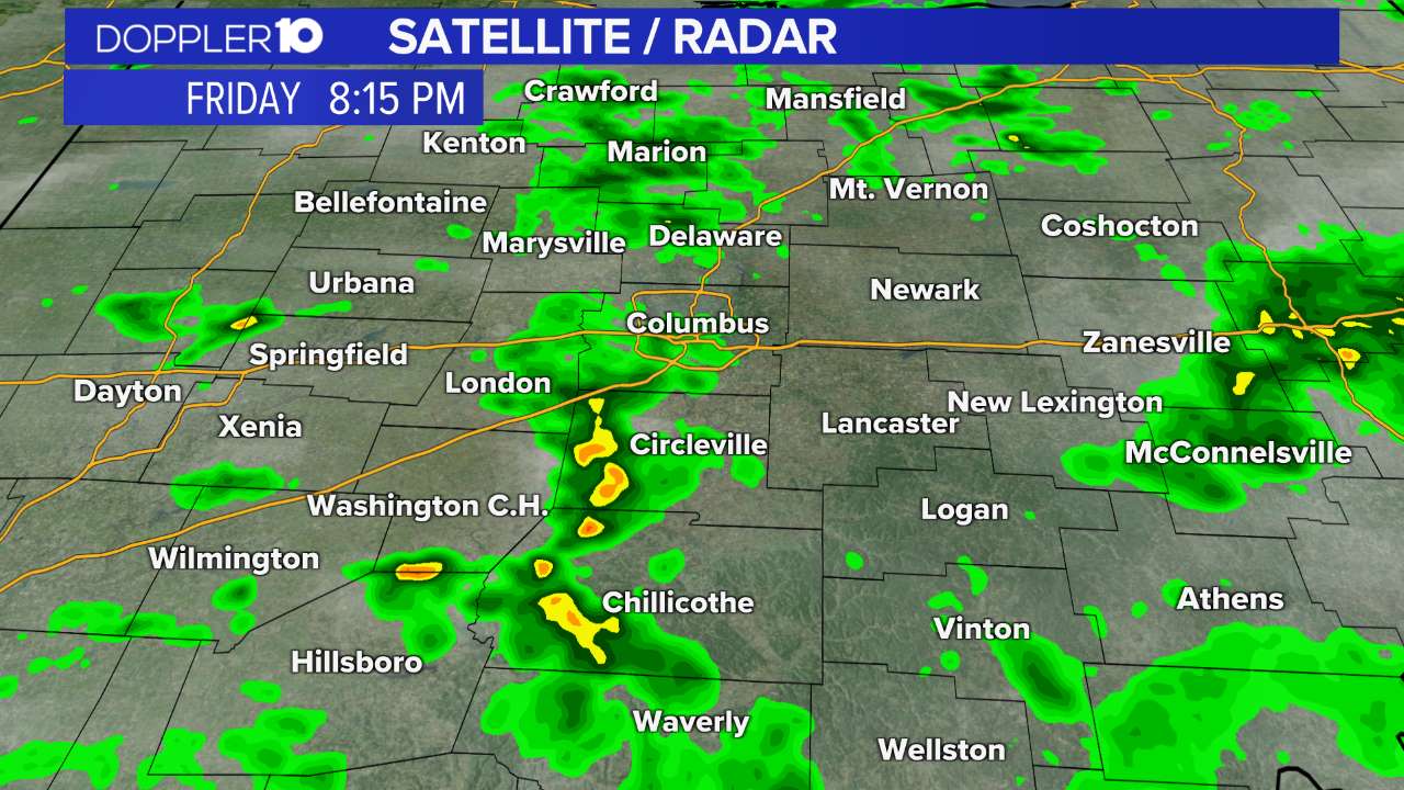
10TV Forecast
Weather News
- Columbus area traffic updates: Crash reports, road closures, backup times
- Midwest tornadoes flatten homes in Nebraska suburbs and leave trails of damage in Iowa
- New color-coded heat risk tool adds a level higher than red
- National Weather Service confirms 5 tornadoes in Ohio during Wednesday's storms
10-Day Forecast
Wed
May 01
82
52
20%
12
MPH
W
Times of sun and clouds. Highs in the low 80s and lows in the upper 50s.
62%
Very High
6:30 AM
8:26 PM
Thu
May 02
83
57
30%
11
MPH
W
A few clouds. Highs in the mid 80s and lows in the mid 60s.
60%
Very High
6:29 AM
8:27 PM
Fri
May 03
81
63
60%
10
MPH
WNW
Afternoon thunderstorms. Highs in the low 80s and lows in the low 60s.
59%
Moderate
6:28 AM
8:28 PM
Sat
May 04
74
62
70%
10
MPH
WSW
Rain with a few rumbles of thunder. Highs in the mid 70s and lows in the low 60s.
48%
Moderate
6:27 AM
8:29 PM
Sun
May 05
77
61
40%
10
MPH
SW
Showers. Highs in the upper 70s and lows in the upper 50s.
48%
High
6:25 AM
8:30 PM
Mon
May 06
75
59
60%
8
MPH
WNW
Showers possible. Highs in the mid 70s and lows in the low 60s.
59%
Moderate
6:24 AM
8:31 PM
Tue
May 07
78
61
60%
10
MPH
NW
Scattered thunderstorms possible. Highs in the low 80s and lows in the mid 60s.
52%
High
6:23 AM
8:32 PM
Wed
May 08
77
63
60%
13
MPH
WSW
Scattered thunderstorms. Highs in the upper 70s and lows in the low 60s.
59%
High
6:22 AM
8:33 PM
Thu
May 09
74
62
20%
12
MPH
W
Afternoon showers. Highs in the mid 70s and lows in the upper 50s.
55%
Very High
6:21 AM
8:34 PM
Fri
May 10
72
56
30%
11
MPH
WSW
Chance of afternoon showers. Highs in the mid 70s and lows in the mid 50s.
56%
High
6:20 AM
8:35 PM
Hourly Forecast
1 PM
Wed
77°
0%
11
MPH
SW
2 PM
Wed
78°
1%
11
MPH
SW
3 PM
Wed
79°
1%
12
MPH
SW
4 PM
Wed
80°
1%
12
MPH
SW
5 PM
Wed
81°
3%
12
MPH
WSW
6 PM
Wed
80°
2%
11
MPH
WSW
7 PM
Wed
79°
3%
10
MPH
W
8 PM
Wed
76°
1%
8
MPH
W
9 PM
Wed
73°
1%
5
MPH
W
10 PM
Wed
71°
2%
4
MPH
WNW
11 PM
Wed
68°
3%
4
MPH
WNW
12 AM
Thu
66°
3%
4
MPH
NNW