

COLUMBUS, Ohio — Eight tornadoes were confirmed to have touched down in Ohio during a round of storms and severe weather on Tuesday, according to the National Weather Service.
An EF2 tornado touched down in Jackson County and EF1 tornadoes touched down in Adams County, Lawrence County and Guernsey County. Two EF1s hit various regions of Muskingum County and EF0 tornadoes touched down in Licking County and Muskingum County.
Jackson County
The weather agency said an EF2 tornado hit Jackson County at 8:47 p.m. and began along Erwin Hollow Road. The tornado lasted three minutes, hit estimated wind speeds of 115 mph, measured 325 yards wide and traveled nearly two miles. The damage includes leveled trees and damage to a home.
Adams County
NWS reports that the EF1 tornado in Adams County began at 7:46 p.m. just south of the intersection of Brier Ridge Road and Robinson Hollow Road, southwest of West Union. The tornado lasted 11 minutes, hit estimated wind speeds of 100 mph, measured 500 yards wide and traveled eight miles. Damage was found along Eagle Creek Road and Tomlin Road, with the Kirker Covered Bridge losing its roofing panels. Other damage includes uprooted and snapped trees and damage to buildings in the area. The NWS also reported that there was one injury due to the storm.
Lawrence County
The NWS confirmed an EF1 tornado touched down in Lawrence County near Aid-Oak Ridge Road at 10:26 a.m. The tornado lasted about one minute, hit estimated wind speeds of 90 mph, measured around 200 yards wide and traveled just over a mile. The storm blew the roofs off of two homes, rolled over a travel trailer and blew panels off a barn roof.
Guernsey County
NWS said an EF1 tornado touched down in north central Guernsey County starting at 8:57 p.m. The tornado lasted for about one minute. The length of the tornado was about 1.3 miles, the max width was estimated to be about 75 yards and wind speeds peaked near 100 mph. NWS said this tornado was associated with the same circulation that produced tornadoes in Muskingum County.
Three in Muskingum County
Two EF1 tornadoes and one EF0 were confirmed in different parts of Muskingum County. The first EF1 started at 8:32 p.m. beginning north of Zanesville at the Parr Airport. This tornado lasted for 12 minutes, had peak wind speeds of 90 mph, traveled 8.25 miles and had an estimated width of 75 yards.
An EF0 tornado started at 8:49 p.m. in central Muskingum County. The tornado lasted for about two minutes with winds peaking near 85 mph, it traveled 1.21 miles and had an estimated width of 50 yards.
The second EF1 tornado which hit southeastern Muskingum County started at 9:20 p.m. The tornado lasted for about one minute, hit estimated wind speeds of 105 mph, measured around 150 yards wide and traveled just over half a mile.
Licking County
The weather agency said the winds reached a maximum speed of 75 mph and was 150 yards wide. Surveyors described the tornado as brief and weak.
Severe storms and heavy rainfall moved through Ohio on Monday and Tuesday. Flooding was also a concern in some areas of central Ohio as the storm system brought heavy rain to the region.
Radar estimates for rainfall from Saturday evening to Tuesday evening topped 3 to 4 inches in some spots, with flooding being the result.


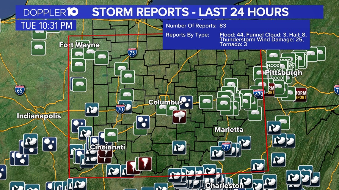
From Monday night to Tuesday night, at least 83 storm reports came from the box outlined in red below. This included 44 flood reports, three funnel clouds, 25 reports of wind damage and at least three tornado reports in southern Ohio.

Severe weather has been making its presence known this spring, with several severe thunderstorms and tornado warnings across the 10TV viewing area over the past week. Thankfully, this recent round spared our region what could have been a severe tornado outbreak.
Doppler 10 Weather Resources