
COLUMBUS, Ohio — Has the expected path of totality for the April 8 total solar eclipse changed?
An updated map reflecting new research shows changes to the expected path of totality for next week’s total solar eclipse. It's instigating buzz around the world, but context is needed.
John Irwin with Besselian Elements recalculated the path using an alternative estimate of the sun’s radius that shows the width of totality is slightly narrower in spots. This would mean that some locations on the very edge of the previous path would no longer be in totality.
However, NASA says its eclipse predictions have not changed.
THE QUESTION
Has the path of totality for the April 8, 2024, total solar eclipse changed?
THE SOURCES
- NASA
- Don Stevens, director of the Perkins Observatory (Delaware, Ohio)
- The Center of Science and Industry (COSI)
THE ANSWER
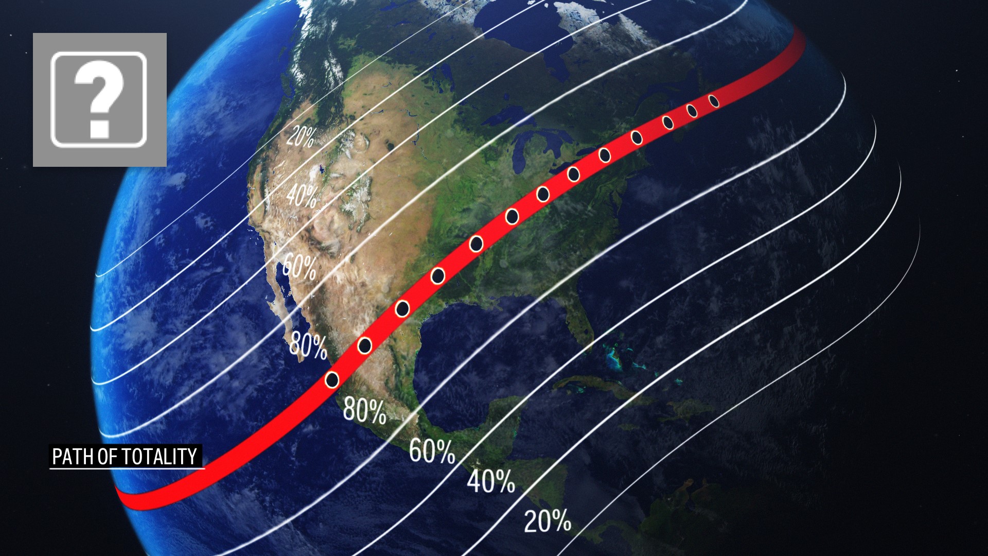
Predictions for the path of totality can differ due to the uncertainty about the size of the sun. Calculations that use a slightly larger radius yield an eclipse path that is slightly narrower, according to NASA.
WHAT WE FOUND
New research published by John Irwin of Besselian Elements shows a narrower path of totality for the April 8 total solar eclipse. Irwin shared his findings earlier this week, saying it provides a reliable guide for those who planned on viewing the eclipse near the path edges.
Irwin said the new path accounts for topographic elevation, both around the limb of the moon and on the surface of the Earth.
Besselian Elements team member Luca Quaglia issued the following statement explaining things from his perspective.
Eclipse maps are computed based on a set of parameters and assumptions. The choice of parameters values and assumptions lead to slightly different eclipse maps.
The eclipse limits in John Irwin's map have been computed using an accurate eclipse computational methodology, using an improved value of the solar radius and accounting for the topography of both the lunar limb and Earth. This leads to a more accurate eclipse map, we believe the most accurate we can achieve with today's knowledge and the closest to reality.
Some other maps use the "standard" solar radius as a parameter. This solar radius was measured more than a century ago, but recent determinations give support to a solar radius slightly larger than the standard value.
Our team of amateur astronomers, the Besselian Elements Team, has given several contributions to the refinement of the value of the "eclipse solar radius" in recent years. You can find links to some of our peer reviewed publications in the publications section of our website.
Why John's map only came out so close to eclipse day? Other parameters are also needed to produce accurate eclipse maps (e.g. deltaT and polar motion) and these parameters are fluctuating and can only be known with certainty when they will be measured on eclipse day. So we need to rely on forecasts. These forecasts become really precise only a few months or a few weeks before eclipse day (the more precise the closer to the date). So John waited till few weeks before eclipse day to collect the most reliable forecasts of these parameters before computing his accurate map.
The map will not change. Differences with other eclipse maps are due to these other maps not using an improved solar radius or not factoring in the topography of the lunar limb and Earth while computing the eclipse limits.
Don Stevens, director of the Perkins Observatory, said measuring the size of the eclipse path itself is like measuring a moving target.
“Basically, it comes down to more accurate determination of the sun's diameter, which you think would be rather straightforward, but it's not because the sun, unlike the Earth doesn't have a solid surface,” Stevens explained.
Our Verify team also heard from the Center of Science and Industry (COSI) which explained that there is always a margin of error with any calculation. “We would like to note that NASA has not changed their prediction based on this other prediction, and the two are not very different from one another,” a COSI spokesperson said.
In response to questions about Irwin’s predictions, NASA said “Calculations that use a slightly larger radius for the size of the sun yield an eclipse path that is slightly narrower. This difference would only affect cities on the very edge of the path of totality, where blanket predictions are difficult regardless – a few city blocks one way or the other could mean 20, 10, or 0 seconds of totality.”
According to NASA, uncertainty in the Earth’s rotation can also affect eclipse predictions.
Traveling toward the center of the path of totality – even a mile or two – will quickly increase the visible duration of totality.
You can check eclipse times on NASA’s interactive map at go.nasa.gov/EclipseExplorer.
Irwin’s map published on Besselian Elements can be found here.