
Less than one week after feeling the full force of Hurricane Paulette, residents of Bermuda are preparing for a strike from powerful Hurricane Teddy, which unlike Paulette, may take a path that could eventually bring impacts to Atlantic Canada and perhaps the northeastern United States.
Paulette brought a wind gust of 117 mph to Bermuda and an island-wide power outage when it passed directly overhead Sunday night into early Monday, Sept. 13-14. More than 20,000 customers were without power following Paulette's approach.
Teddy first developed in the central Atlantic on Saturday, Sept.12. It has since strengthened into a Category 3 major hurricane on the Saffir-Simpson Hurricane Wind Scale. Laura is the only other Atlantic storm to achieve major hurricane status so far this season.
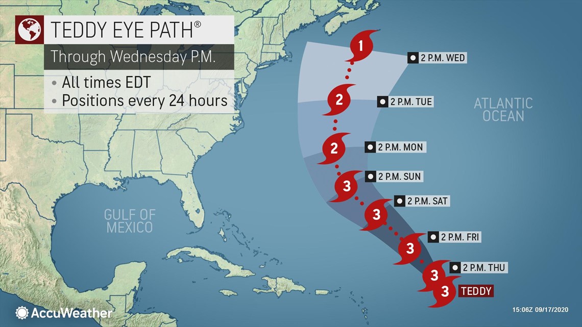
As of 2 p.m. EDT on Thursday, the storm was packing maximum sustained winds of 120 mph and was located more than 1,100 miles southeast of Bermuda while moving at a speed of 12 mph.


Teddy is currently forecast to be more intense than Paulette as it makes its closest approach to Bermuda.
Teddy could peak at Category 4 strength prior to reaching Bermuda. AccuWeather Senior Meteorologist Rob Miller expects Teddy to pass near Bermuda late Sunday night into Monday as a Category 2 or 3 hurricane.

The impacts, however, will depend on how close the center of the storm passes to the islands. The closer the center of the storm, the greater the impacts will be.
AccuWeather's current Eye Path® takes Teddy nearly right across the islands. Similar to Paulette, this would bring Teddy's worst conditions to Bermuda.
On this track, Teddy would bring another round of damaging winds and flooding rainfall.
However, even a glancing blow by Teddy can still have significant impact on the islands due the hurricane's current large size. As of the mid-afternoon hours on Thursday, tropical-storm-force winds of at least 39 mph extended outward by up to 255 miles from the center.
After passing Bermuda, Teddy is expected to continue on a north-northwesterly track which would cause the hurricane to approach Atlantic Canada or northern New England around the middle of next week.
"If Teddy takes a northerly track, areas from Nova Scotia to Newfoundland would be the most likely to see impacts. Teddy may still be a hurricane at this time with impacts including potentially damaging wind gusts, heavy rainfall and pounding surf," Miller explained.
Another scenario would have Teddy track farther to the east and miss Atlantic Canada on the storm's trek into the North Atlantic.
These appear to be the two most likely scenarios.
"There remains the chance that Teddy is pulled more to the northwest and could impact northern New England before curving across Atlantic Canada and into the North Atlantic," Miller said.
This could bring strong winds, heavy rain and coastal flooding to much of the New England coastline.
A hurricane has never hit Maine from any direction other than from the southwest, according to AccuWeather Senior Weather Editor Jesse Ferrell.
"Only eight hurricanes have hit Maine on record with only three of those since 1950," Ferrell said. "Bob in 1991 was the most recent and only the Unnamed 1869 hurricane, Bob and Gerda from 1969 were Category 2 when they hit with the remaining storms being Category 1 strength."
According to Colorado State University Meteorologist Phil Klotzbach, the average date for the second major hurricane formation in the Atlantic is Oct. 3.
Regardless of the final track and impacts from Teddy, even if the hurricane remains out to sea, forecasters warn that rough surf and dangerous rip currents are possible along the New England and mid-Atlantic coasts this weekend and early next week.
Small craft should avoid venturing too far offshore as monstrous waves could develop from and propagate toward the coast from the large hurricane.