

It is almost the middle of summer and all is quiet in the tropical Atlantic, but for how long?
Despite the bumper crop of tropical storms thus far, several of which have formed the earliest on record since the start of the weather satellite era, July often brings quiet times for the Atlantic basin in terms of activity.
This is due to the northward retreat of the jet stream which prevents cold fronts from moving over warm waters of the Gulf of Mexico and the western Atlantic. Fronts are often the starting point for tropical depressions and storms early in the season.
One such old frontal boundary assisted with the birth of Tropical Storm Fay just last week along the Atlantic coast of the United States.
There are usually vast areas of dry air, dust and wind shear present over the Atlantic basin during July. And these conditions are certainly present over much of the basin at this time.
Wind shear is the change in the speed of the movement of air at different levels in the atmosphere and the change in direction of air flow across the horizontal part of the atmosphere. When wind shear is strong, it can prevent a tropical storm from forming or cause a hurricane or tropical storm to weaken.
Even though waters are warm in July, sea-surface temperatures typically do not peak until later in August.
Despite these factors weighing against tropical storm formation in the coming days, there are a few areas, near and far, that AccuWeather meteorologists are monitoring for possible future tropical development.
The first feature or features are the train of disturbances that originate over Africa and move westward over the Atlantic. These disturbances are known by forecasters as tropical waves. These waves may start as thunderstorms over tropical Africa or dust storms over the Sahara Desert. Most of these fail to develop as they move along, but a small number can gather spin and develop into tropical depressions, storms and hurricanes.

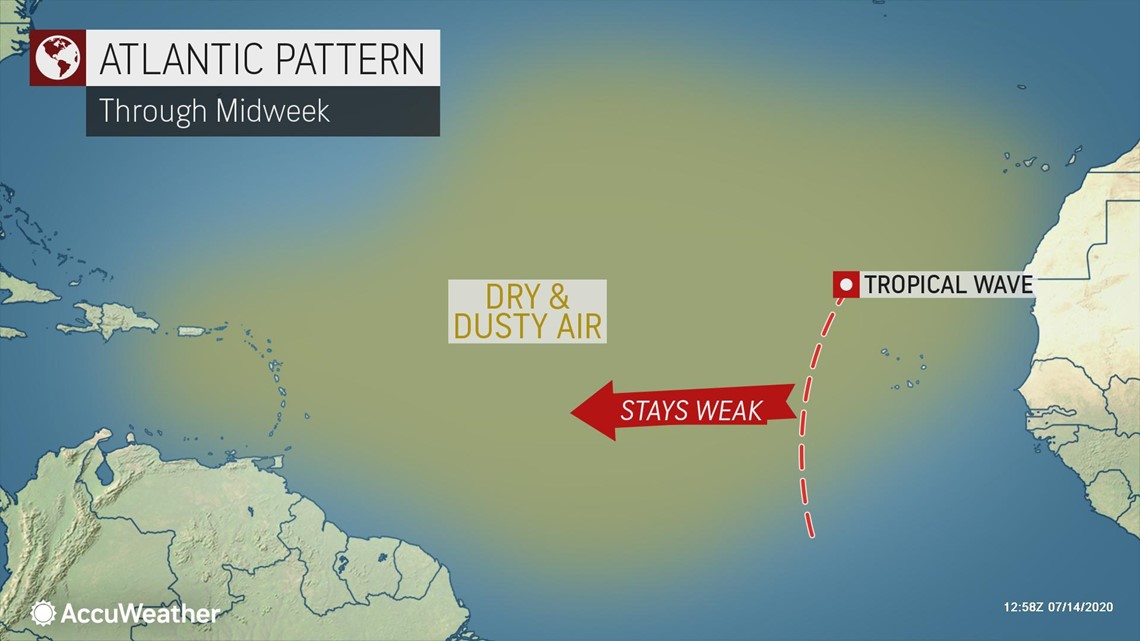
A couple of tropical waves were along the edge of the dry air and dust on Tuesday. However, as they move westward they are likely to move into a zone of more hostile conditions for development later this week over the middle of the Atlantic and toward the Leeward and Windward Islands.
Closer to home, the leftover part of an old thunderstorm complex will move southward to along the upper Gulf Coast at midweek and then drift westward over the weekend.

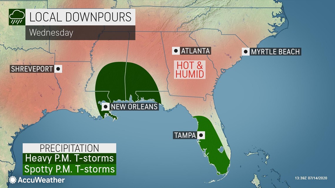
"Proximity to the coast and the disturbance's very weak state will probably not allow enough time for development before pushing onshore in Texas Friday night or Saturday," according to AccuWeather Senior Meteorologist Rob Miller.

The system can trigger showers and thunderstorms as it moves westward over the northern part of the Gulf of Mexico and adjacent areas from the western part of the Florida Panhandle to Texas.
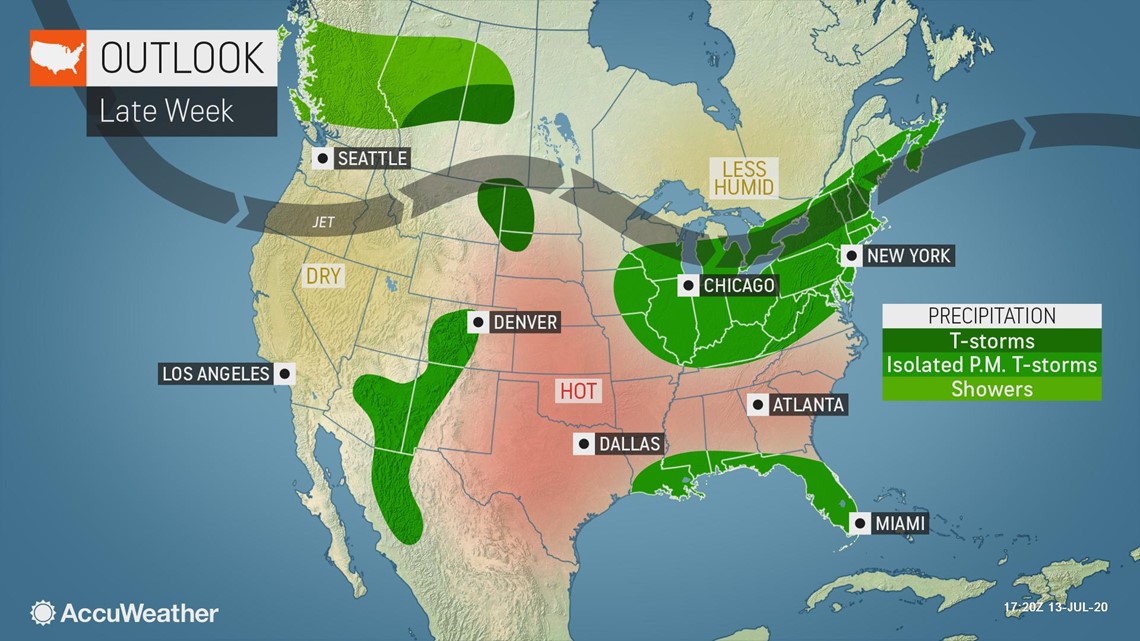
Another pulse in showers and thunderstorms is projected to take place over the Gulf of Mexico from Sunday to next week.
"Factors for slow development are an increase in moisture over the Gulf and the warm water early next week," Miller said, noting that water temperatures are generally in the mid- to- upper-80s over the region, which is plenty warm to allow for further development. "But wind shear may be too strong to allow a tropical system to develop and catch on."
Formation of tropical systems in the Gulf of Mexico during the middle of July is quite rare, despite Hurricane Barry from last year. Barry strengthened into a Category 1 hurricane before making landfall in central Louisiana on July 13, 2019.
"Only four tropical systems have developed during the stretch from July 11 to 20 in the Gulf of Mexico over the last 170 years," AccuWeather Senior Meteorologist Mike Doll said.
There have been six tropical storms so far in 2020 over the Atlantic basin: Arthur, Bertha, Cristobal, Dolly, Edouard and Fay. The average first date for a tropical storm is July 9, but Arthur formed way earlier on May 17. Bertha followed quick on the heels of Arthur, also forming prior to the official start of the 2020 Atlantic hurricane season, which began on June 1.
The 2020 season has been so far ahead of average that the third, fifth and sixth named storms -- Cristobal, Edouard and Fay, respectively --each became the earliest storm by number for the basin. None of the storms thus far this season have strengthened into hurricanes, but the average date for the first hurricane of the season is not until Aug. 10.

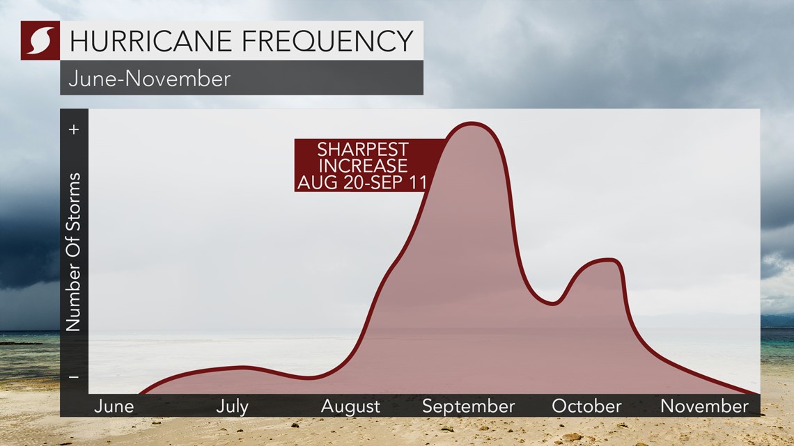
The number and intensity of tropical systems typically increases dramatically during the latter half of August through early September, with the peak of hurricane season considered to be around Sept. 11. Hurricane season runs through Nov. 30.
AccuWeather is projecting a busy season ahead with 14-20 named tropical storms, seven to 11 hurricanes and four to six major hurricanes -- Category 3 or higher. Five tropical storms are already in the books for the season, with two U.S. landfalls.
The next two named storms on the Atlantic list for 2020 are Gonzalo and Hanna.
The 2005 hurricane season also holds the earliest dates for tropical storms through the letter "K" when Katrina formed on Aug. 24. Gert formed on July 24, 2005, followed by Harvey on Aug. 3. The name Harvey would eventually be retired after the 2017 season when a different Harvey brought devastating flooding to Texas.