10/31 Thursday Morning Update:
Fog lingers this Halloween morning making it feel extra spooky out. It won't feel much like Halloween later tonight, though. Some tweaks to the forecast now have the bulk of the rain moving out by the early afternoon today. Unfortunately, this allows the winds to pick up even more and the colder air to build during the peak Trick-or-Treat hours.
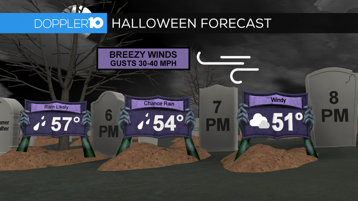
Spotty rain will linger this evening, but the main story will be the winds. A wind advisory will be in effect starting at 3 pm today until 2 am Friday. Winds will gust up to 40-50 miles per hour at times this evening, right in that 6-8 p.m. timeframe. Not only that, but the air will get cold quick. We'll be in the 50's early this evening and will then take a dive into the low 40's by 8 p.m. Coupled with the wind, it will feel like it's in the 30's and 20's later this evening.
So when is the best time to head out? Shortly after the bulk of the rain moves out this afternoon, there will be a small window of opportunity. 2-5 p.m. is looking like the best time to get out because this will be after a cold front moves through and winds won't be as strong. It will still, of course, be damp, breezy with some spotty rain around this time, but it will be much better than what's in store this morning and this evening. The extra layer will be needed, especially if you still plan on going out this evening.
And to make things more "interesting', we could see our first wet snowflakes of the season! Better chances for some flurries north of I-70 late tonight into the early overnight. Tomorrow morning will then be much colder with temperatures near freezing and wind chills in the 20s and teens! Now that's scary.
10/30 Wednesday Afternoon Update:
Rain remains in the forecast, but there looks to be more agreement on when the bulk of the rain will move through. Fortunately, most of the heavy rain will be well past central Ohio by Thursday evening. That doesn't mean there won't be rain around, though. While the bulk of the rain will be done with during peak Trick-or-Treat hours, there will still be some spotty showers around the area, so the umbrella should still be taken out with you.
While the rain moves in sooner, that's not necessarily making conditions "more pleasant". As rain wraps up, winds pick up. Wind gusts will be gusting anywhere from 20-40 miles per hour in the evening. The stronger gusts will occur later at night.
Along with the winds, temperatures will be dropping pretty fast into the night. Most of us will be in the mid 50's around 6 p.m. Temperatures will then drop quickly into the upper 40's by 9 p.m.
Put on that extra layer and make sure you have good grip on that umbrella.
10/29 Tuesday Evening Update:
Rain is still in the forecast on Halloween and it still looks like a soaking rain is still on the way for central Ohio. But there are a few subtle changes in the forecast.
The first is the timing of the rain. It still looks like rain will start moving into the area on Wednesday afternoon. Off & on rain will continue into Halloween with steady to heavy rain Halloween morning and early afternoon.
Right now the latest model data has the steadiest rain hitting before trick-or-treating; at least in Columbus. Folks who are east of the city will have the potential for steady to heavy rain at the beginning of beggar’s night with rain trending down from 5-8 p.m.
Here in Columbus rain will linger into the early evening but it won’t be as heavy. There still a chance for some light showers but the bigger issue we’ll be dealing with is gusty winds.

Thursday is looking to be fairly breezy but the winds will really kick up once the heaviest rain moves out behind a cold front. This means that the areas that are watching things dry out will start to see the winds increase.
So a cool, damp & raw night is expected in Columbus and areas west of it. More rain, but not as windy for folks who are east of the city.
Once all is said and done roughly an inch or so of rain will be possible and wind gusts will top out in the 40-50 mph range in some areas by late Thursday night and Friday morning.
There are still some tweaks to be made to the forecast as we get more data so keep checking back for the latest forecast from the Doppler 10 Weather Team.
Stay tuned for more details.